A winter storm watch was been issued for a system expected to dump several inches of plowable snow across Massachusetts early next week.
The winter storm watch was issued by the National Weather Service Saturday afternoon for Central Middlesex County; Eastern Essex; Eastern Franklin; Eastern Hampden; Eastern Hampshire; Eastern Norfolk; Eastern Plymouth; Northern Bristol; Northern Worcester; Northwest Middlesex County; Southeast Middlesex; Southern Worcester; Suffolk; Western Essex; Western Hampden; Western Norfolk; and Western Plymouth for the storm expected to reach New England Monday night into Tuesday morning.
The track will pass offshore Monday night to Tuesday morning with the highest snow totals falling inland and decreasing down to the south coast and Cape.
Boston 25 Meteorologist Tucker Antico says most of the region should expect to have their Tuesday morning commutes impacted.
“Tuesday’s nor’easter will pack a punch with heavy snow occurring in the morning,” says Antico.
FIRST CALL SNOW TOTALS
— Tucker Antico (@tuckerweather) February 11, 2024
Tuesday’s nor’easter will pack a punch with heavy snow occurring in the morning. Coastal flooding will become a concern in the early afternoon.
Everyone will see plowable snow and significant impacts through the first half of the day. pic.twitter.com/yYuZmGeOZQ
As the day continues, coastal flooding will become a concern in the early afternoon, Antico adds.
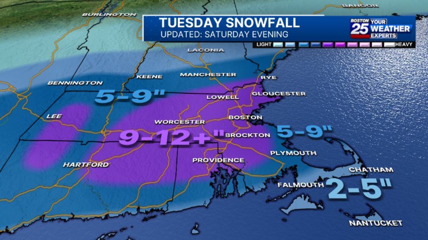
Most of eastern Massachusetts, along with northern areas of New Hampshire and Rhode Island may see between nine inches and a foot of snow. The South Shore will likely see five to nine inches and Cape Cod can see two to five inches.
“I expect nearly everybody to enjoy a snow day on Tuesday!,” Antico says
Stay with the Boston 25 Weather Team for updates as the storm forms and gets closer.
This is a developing story. Check back for updates as more information becomes available.
Download the FREE Boston 25 News app for breaking news alerts.
Follow Boston 25 News on Facebook and Twitter. | Watch Boston 25 News NOW
©2024 Cox Media Group
/cloudfront-us-east-1.images.arcpublishing.com/cmg/7QOJU3BNCJERBNKJC5LWTBYFLU.png)